Tuesday, August 28, 2007

The anti-nuke Google mashup from Action West

An interesting Google maps mashup at http://www.stopnewnukes.org/ from the team at Peace Action West - this one maps all the nuclear facilities in the country (do we really want to be sharing all this info and making it so readily available?) and then provides additional info as well as a link to sign a petition to stop the facility. Obviously this resource caters to the anti-nukes crowd but you see they are we're going with it. A nice UI and clever app for this organization - please note: I'm simply sharing info about the map mashup and don't endorse the anti-site or nuclear facilities in any way - I'll just stay neutral here! This takes me back to my poli-sci days and I have to admit that I'm likely from the camp where the best defense is a good offence!

Tuesday, August 21, 2007

Tutorial - Create a Google MyMap, add your flickr photos from a Mapplet, then embed

As of this week, adding a Google map, or even better, your Google "MyMaps", to your webpage is a snap (pardon the pun). You know how simple it is to embed a youTube video into your blog? Well, it's that simple. Here's a short tutorial to show you how simple it actually is. We'll create a custom google MyMap, add a Mapplet, embed some photos from our flickr account, save the map, and embed it within a website (in this article)... no problemmo! To finish I'll offer up a couple of photo geotagging tools for those of you with GPS-enabled cell phones and a tool for mannual geotagging for those with no access to GPS. If you enjoy Google maps, flickr, and geotagging photos then this tutorial is for you.

A photo tip - embed your flickr slideshow into your blog in seconds

Wow, just stumbled onto an awesomem flickr slideshow tool... you know that I'm a flickr fanatic, however, I didn't know about this app so I hope you enjoy as much as I do... this one will be really handy so be sure to bookmark this post! FlickrSlidr allows users to easily and quickly embed a flickr slideshow into your website(or blog). Alter the size, the flickr set to display, and then mess with the speed. See below for a slideshow of my 2007 ESRI User Conference photos.. enjoy!


Created with Admarket's flickrSLiDR.

Embed your Google map (MyMap) into your blog, or website with youtube-ish ease

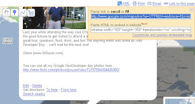
Another cool tidbit today out of the Google camp is embeddable maps in your blog.. think embed a youtube video into your blog and you'll know what I mean. Google has made it way simple to now embed your custom google maps (MyMaps) into your website. Simply open a map, click the "link to this page" link (upper right), copy the code, then embed into your map! Screenshot of this is below and the actual embedded map is provided at the bottom.. way cool.. thanks Google Maps team!

Embedding your gogole map is now a breeze, with youTube embed-like functionality!

See my Google MyMap below! Note: I've altered the default size


View Larger Map

Real Time traffic in Google earth

We've had traffic updates available in Google maps for some time, however, the Google Lat/Long blog has informed us that real-time traffic reports are now available for viewing in Google Earth.. nice! Simply enable teh traffic layer and view updates... pretty simple.


Monday, August 20, 2007

Wirecast software (podcasting) + Ogle Earth = Google Earth TV

Cool stuff from Stefan over at Ogle Earth as he's put together a very clever demo of some wow technology. Using software from Wirecast, his notebook, a green sheet, and Google Earth he's put together Google Earth TV. It's a bit rusty (don't give up your day job to become a news caster Stefan ;0) but you get the point of the type of thing "anyone" can accomplish using the right tools...nice stuff! Video provided via YouTube.

What's your favorite Google earth app?

What's the coolest, strangest, most interesting, most innovative or most useful thing that you like to do with Google Earth? Many of us regularly use G. Earth to track hurricanes, sightsee, check out National Geographic magazine, shop for real estate, or ??? I'm interested in hearing about what you'd must have Google Earth utility or tool is. Please share a small description and a website and/or KML link... I'll be summarizing some of the findings and sharing with readers. Respond with a comment or simply blast your submission to googlefun@gisuser.com - what's one of my favorite things to do in Google Earth? Well, I like to check out the recent earthquakes recorded by the USGS (http://earthquake.usgs.gov/eqcenter/catalogs/eqs7day-age.kmz) its also cool to explore the Arctic. On a related note, I also am a fan of shopping on craigslist so the allurstuff app is way cool for an interesting gmaps mashup! Once again, send your submission to googlefun@gisuser.com

Friday, August 17, 2007

Topographic map layers for Google Earth (KML)

The following links provide topographic map overlays for several countries

Follow Hurricanes Dean and Erin with Google earth

Hats off to Frank Taylor over at the Google Earth Blog once againn... Frank has provided a very handy utility for those of you (like me) who enjoy watching and chasing storms and weather related information. Using this habdy utility (http://www.gearthblog.com/kmfiles/gebweather.kmz) within Google Earth you'll have access to al the latest severe weather related data that you can ever need. Access real-time stream guage data, satellite imagery, web cameras, predicted tracks, lightning strikes, cloud cover, and much more. As we enter another hurricane season and follow the paths of hurricane Erin,m Dean and others this will no doubt be a very popular toolset. Kudos Frank and thanks!

Saturday, August 11, 2007

The Windsor, CO Police Speed Trap Google map mashup!

Yesterday I wish I would have had access to some known police hangouts via Google maps.. heck, there likely is a mashup out there that does this (there's one for everything else). After 25 years of clean driving I managed to get pulled over doing 40 in a 30 zone (I know, big freaking deal!) To help in my rehabilitation I've added a Police Speed Trap zone to MyMaps and maybe it will save some other unlucky sucker from falling into the same "trap" that I did. FYI, have you checked out the icons that are now at your fingertips in Google maps lately? Its a breeze to share a map like this with others, taking about one minute to create. Now if all of Windsor can pitch in and help map the rest of the traps we'll have a really useful resource ;0)


Loads of cool icons are now available for placing on your MyMap

Sunday, August 5, 2007

USGS Topo maps layer for Google Earth

I spent this morning flying around Northern Colorado looking for a place to swim in the Poudre River near Fort Collins (any ideas??) - I then had a need to add a USGS topo layer to my Google Earth session - enter good old Frank Taylor (aka. Google Earth Blog founder) and a solution! A great add-on for Google Earth from a company called 3D solar was found, enabling you to view USGS topos for your area of interest was located easily seaching his blog. Simply add the layer, wait a few seconds and the topo will appear.. toggle off when you don't need it... I'd love to see the ability to swipe the topo in/out with the google earth scene! Developed by 3D solar and KMZ streamed from the Google earth blog - here's the USGS topo layer KMZ.. enjoy! http://www.gearthblog.com/kmfiles/topomaps.kmz

Thursday, August 2, 2007

City of Nanaimo and more kudos from the media - here's details on what Nanaimo serves up for Gogole earth users

The City of Nanaimo, BC (that's on Vancouver Island where I used to live) is getting some great attention thanks to some recent comments from Gogole CTO Michael Jones made at GeoWeb event, Vancouver. An article hit the Victoria Times Colonist online but really didn't say too much unfortunately. From the article... With the quick click of a mouse, Google Earth will provide any Internet user with a 3-D image of buildings in downtown Nanaimo or the curved streets that cover the city's north end. That's pretty much all that the reporter provides their readers. Unfortunately they didn't really delve into the who, what, where, when, why or how to really explain the story.. too bad!

Of interest, I noted a year ago how the City of Nanaimo was putting their data up in KML and provided some detailed information about what users could do with these data. See the article here

Interesting to note that The City of Nanaimo is also very proactive AutoCAD house and user of OSGeo technology - aka MapGuide Open Source. The city's "GIS guru", Jason Birch has garnered pretty much zero attention or recognition in any of the recent press.. too bad as Jason has been quite instrumental in getting Google Earth data rolling out of the city's website.. Jason, you still there?? He's also their MapGuide expert and very involved with the open source movement. You can follow Jason on his Random Nodes blog - (hey Jason, where's the link to AnyGeo blog ;0)!!


Suggested Web Resources:

Add Maps to your cutom Google homepage (iGoogle) or your Google MyMaps

Imagine having the following on your desktop and constantly updating for you in real time...
traffic reports
world news headlines
KML samples
photos ser4ved via KML
a world sunlight map
images from Googleplex
Google map search
weather channel maps
virtual earth maps
traffic cams
mapquest driving directions
map of things to do in Sydney Australia
Yahoo! local maps
listing of map mashups from programmable web

These are but a few of the tools (map gadgets) now available via the Google Heomepage (custom) add stuff directory. Its also easy to add these as Mapplets to your Google Maps... The directory is accessed by clicking on the "Add content" link in the "My Maps" tab in Google Maps.

To add "Map" mapplets to your iGoogle custom homepage simply do the following:
- sign in to your google account
- go to your custom home page
- create a new tab, maybe call it "Map Stuff"
- Click Add Stuff (right side)
- Search homepage content using "maps"

For more information including documentation on how to create your own mapplet see http://www.google.com/apis/maps/documentation/mapplets/
Don't forget you'll need an API key - see http://www.google.com/apis/maps/signup.html